
The Temple Ambler Field Station overlays the 187-acre (75.6-hectare) Ambler Arboretum of Temple University and Ambler Campus The Field Station includes several ecosystems including forests, meadows, wetlands and streams. These areas serve as an outdoor classroom and living laboratory for students and researchers at the Field Station.
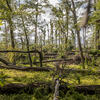
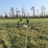
Forests: Six forest patches totaling 75.6 acres (30.6 hectares) in various stages of growth and regrowth may be found at the Temple Ambler Field Station. These forests are dominated by American Beech, Tulip Poplar, Red Maple, and Black Walnut. One forest patch, the Temple Forest Observatory a dedicated research area on the southernmost edge of the Field Station that is not open to the public, serves as a focal site for studying forest recovery following a tornado that struck this once-mature forest of tall trees in 2021.
In contrast, the BioBlitz Woods, located on the easternmost part of the Field Station, features a well-maintained trail system that offers visitors easy access to explore the landscape.
The Conservation Woods, at the northernmost part of the Field Station, is a less accessible open woodland site with abundant wildlife. The Old Orchard Woodland, on the southeastern part of the Field Station, is the site of long-term succession from a former orchard.
The Wetland Woods in the western edge of the Field Station offers dense secondary forest growth centered on a stream and small permanent pond. Shoemaker Woods forms the southwest edge of the Field Station and is the site of forest recovery and harbors an agricultural and residential site of historic importance.
Meadows: The Temple Ambler Field Station includes five meadow patches totaling 6.2 acres (2.5 hectares). These include a successional meadow, a wet meadow, a conservation meadow, a research meadow and a restoration meadow, each with a distinct history and management approach.
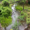
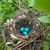
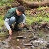
Aquatic and Wetland Environments: The Temple Ambler Field Station is home to the headwaters of two ephemeral streams, Tannery Run and the south branch of Rose Valley Creek, each of which traverses the full length of the Field Station — about 0.6 miles (~1 km) each.
Tannery Run passes through BioBlitz Woods, the Old Orchard Woodland and the Temple Forest Observatory. The south branch of Rose Valley Creek passes through the Conservation Woods, the Wetland Woods and Shoemaker Woods. Adjacent areas form a stream floodplain that covers 20.3 acres (8.2 hectares) of the Field Station. Downstream of the Field Station, these streams connect as separate tributaries to the Wissahickon Creek, which ultimately flows into the Schuylkill River as part of the Delaware River Watershed.
Two ponds are found on the Field Station with a total area of 2.2 acres (0.9 hectares). These include a permanent pond, Lost Pond, located in Wetland Woods, and a seasonal pond/wetland, Blackbird Pond, located in Shoemaker Woods.
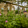
Designed Gardens: 18 cultivated gardens designed and managed by the Ambler Arboretum of Temple University, totaling 5 acres (2 hectares), each specialized to highlight natural features, including a native plant garden, a woodland garden, a sustainable wetland garden and a climate resilient garden.
Other green spaces: Turf, mall, recreational fields, and other open space: 34.6 acres (14 hectares).
These natural environments and gardens support a diverse assemblage of species, including more than 1,000 unique taxa identified to date. Information on current temperature and soil condition is also available. Learn more about the natural areas of the Field Station at the interactive Field Station Sustainability Map; click on the “Field Station” tab.
Partner Site: Robbins Park Environmental Education Center
The Temple Ambler Field Station has a close partnership with Robbins Park Environmental Education Center. This park, jointly managed by Upper Dublin Township and the Upper Dublin School District, is a 38-acre (15.4 hectare) nature preserve and environmental education center located adjacent to the Field Station. It includes a mature forest that was once similar to the Temple Forest Observatory (TFO). Robbins Park, however, was untouched by the 2021 tornado. It represents an excellent reference site for comparison with the recovering TFO forest. A tranquil permanent pond known as Creepy Pond and a 0.3 mile (0.47 km) stretch of the north branch of Rose Valley Creek are also found within Robbins Park.