Contrary to the name, 100-year floods do not unleash their wrath once each century. As Ambler Borough residents and their neighbors can attest, numerous 100-year flood events in recent years — including Hurricane Irene and Tropical Storm Lee in 2011 — have resulted in extensive damage and flooded homes through the region.
With support from $177,000 in grants from the United States Environmental Protection Agency and the U.S. Army Corps of Engineers, the Center for Sustainable Communities at Temple University Ambler is completing a stormwater management plan for three urban watersheds in Ambler Borough and Whitpain and Upper Dublin Townships — Rose Valley, Honey Run/Stuart Farm and Tannery Run.
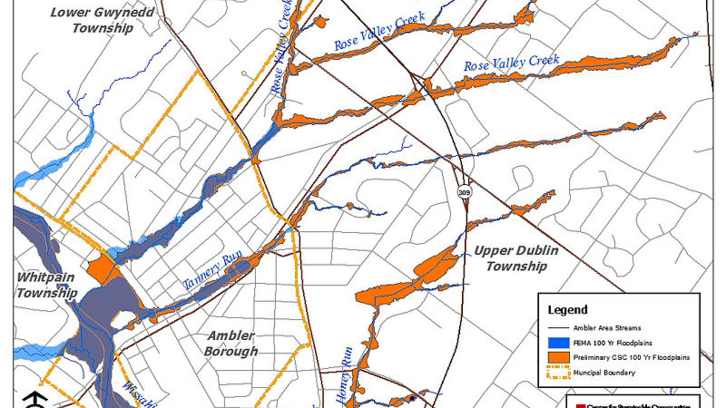
The Center presented key findings of the flood mitigation and stormwater management study along with preliminary floodplain maps during a public meeting on November 12 in Ambler Borough. The draft report is available online.
The Center plan has identified and prioritized stormwater improvements to "mitigate water quality and flooding issues that the municipalities have faced for many years," according to Dr. Mahbubur Meenar, Assistant Director of GIS Operations and Research with the Center for Sustainable Communities who is serving as the Principal Investigator for the project.
"Our research included field data collection and verification, modeling, stormwater management facilities inventory, and assessment of stormwater improvements, their impact on water quality, and their implementation strategies," said Meenar. "We have developed new floodplain maps and a high quality GIS database that will be available to township engineers and other interest groups. Community engagement was essential for this project — we needed to know what the residents, business owners, landlords, municipal officials have experienced during these major flood events."
The first step in acquiring funding to fix flooding and stormwater management issues "was to get a clear picture of where those problems are," said Dr. Jeffrey Featherstone, Director of the Center for Sustainable Communities and co-Principal Investigator for the flooding mitigation project.
"The people who lived through these storms know best how they affect them and their communities — there is a great deal of invaluable information to learn from their firsthand experiences," he said. "One of our recommendations is the extension of a channel of Rose Valley Creek from the Wissahickon Creek to the railroad bridge in the borough — that's the chokepoint. It's an area that gets overwhelmed by large storms."
Were this extension to be put in place, Featherstone said, "instead of ponding in Ambler, that water would be routed to the Wissahickon." Constructed wetlands, extended detention basins and other green infrastructure would have to be put in place, he added, to prevent problems downstream.
"The preliminary floodplain maps are bigger and cover areas that were not included before," he said. "A particular area along the lower Rose Valley Creek is not currently on the FEMA (Federal Emergency Management Agency) floodplain maps. These changes will protect homeowners and business owners in the long run by updating and clearly delineating the areas within the borough that are prone to flooding."
The Ambler-area study builds upon comprehensive research conducted by the Center on the 64-square-mile Wissahickon Creek Watershed, of which the Rose Valley, Honey Run/Stuart Farm and Tannery Run tributaries are a part.
"Based on prior research in this region, we strongly endorse the use of stormwater Best Management Practices, or BMPs, as the preferred means to achieve improved water quality and flood-loss reduction through groundwater recharge and retention, stream bank protection and volume control," said Dr. Featherstone. "As this watershed is essentially built-out, the team has concentrated much of its research on identifying opportunities for retrofitting existing stormwater facilities and finding locations for new practices in areas that are not currently served by them."
To learn more about the project, visit amblerwatersheds.wordpress.com.